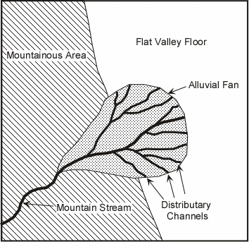
مخروط افکنه Alluvial Fans
مخروط افکنه: (Alluvial fan)
مخروط افکنه، مکانی پست، و نسبتا صافی است برای رسوبگذاری آرام و تدریجی مواد حاصل از فرسایش سنگ ها که در نتیجه این رسوبگذاری مخروط افکنه شکل بادبزن باز یا بخشی از مخروط را به خود می گیرد. محل تشکیل مخرو ط افکنه افکنه حواشی کوهستان ها است.هر قدر از کوهستان به طرف دشت برویم ازضخامت آن کاسته و بر وسعت آن افزوده می شود . یک کانال در قسمت ابتدائی مخروط وجوددارد که رسوبات آواری را از مرتفع ترین نقطه کوهستان به طرف دشت می آورد. این رسوبات در مقطع طولی به فرم مقعر ودرمقطع عرضی به شکل محدب است که درسطح آن بریدگیها، رودخانه ای دیده می شود.
مخروط افکنه از نظر ژئومورفولوژی ، زمین شناسی وبه ویژه رسوب شناسی با حوضه ی آبخیز خود ارتباط مستقیم دارد. بنابر این بررسی منشا رسوبات مخروط افکنه ، فرسایش حوضه آبخیز و وضعیت رسوبزایی سازندها را نیز اشکار می کند . که می تواند در برنامه ریزی آتی حوضه آبخیز ومخروط افکنه به کار رود .
به طور متوسط شیب مخروط افکنه در حدود 5درجه است ولی ممکن است بین کمتر از 1 درجه تا 10 درجه تغییر کند که غالباکمتر اتفاق می افتد این شیب بیشتر از10 باشد. از نظراندازه رسوبات مخروط افکنه ممکن است شعاعی کمتر از چند صد متر تا بیش از150کیلومترداشته باشد که غالبا حد متوسط ان کمتر از10 کیلو متر است .
مخروط های افکنه به علت این که در یک محیط اکسید اسیونی تشکیل می شوند غالبا دارای رنگ قرمز می باشند . شکل هندسی این رسوبات به وضعیت تکتونیکی و آب وهوایی منطقه بستگی دارد . رسوبات قدیمه مخروط افکنه ای در بین رسوبات کنگلومرائی (دانه درشت) نسبت به رسوبات محیطهای دیگر خیلی کمتر است ولی شناسائی آنها به تشخیص تکتونیکی منطقه کمک فراوانی می نماید . اگر چه بیشتر رسوبات مخروط های افکنه در مناطقی تشکیل می گردد که دارای آب وهوای خشک ونیمه خشک با پوشش گیاهی کم وبارندگی خیلی کم وتخریب سریع است ولی این رسوبات مربوط به آب وهوای خاصی نمی باشد ودر مناطق مختلف تشکیل می گردد به طور کلی شرایط آب وهوایی مبنای خوبی برای تشخیص رسوبات مخروط افکنه است . در آب و هوای خشک مخروط افکنه کوچک و دارای شیب زیاد ولی در مناطق با آب وهوای مرطوب شیب سطح مخروط کم واندازه آن بزرگ است . علاوه بر آب و هوا عواملی مثل مقدار آب ، اختلاف ارتفاع ونوع سنگهای موجود در منشا در اندازه مخروط افکنه ، ,سیستم آبگیری ، رسوبات پلایائی ,دریاچه ای,رودخانه ای ، موثر می باشد .
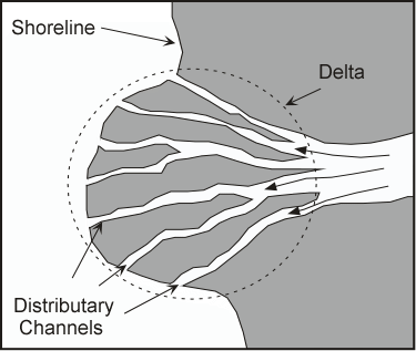
رسوبات مخروطهای افکنه ای به طرف دشت به دلتائی ویا دریائی ختم می شود که گاهی اوقات پس از ورود به دریا تا اعماق زیاد نیز پیش می رود .
از نظر اقتصادی شناسائی رسوبات مخروط افکنه ای از اهمیت خاصی برخوردار است . برای مثال رسوبات مخروط افکنه ای مرکز تجمع آبهای زیر زمینی می باشد ونیزبیشتر مخازن آبهای زیر زمینی درون حوضه رسوبی از آبهای وارده به رسوبات مخروط افکنه ای تغذیه می شوند . همچنین بیشتر طلای موجود در دنیا از رسوبات مخروط های افکنه قدیمه در آفریقای جنوبی استخراج می گردد که به فرم پلا سر بر جای مانده اند ضمنا مقذار زیادی اورانیم پلاسر از رسوبات مخروط افکنه ای قدیمه در حوضه های رسوبی آفریقای جنوبی استخراج می گردد .
رسوبات مخروط افکنه:
رسو بات مخروط افکنه تحت تاثیر دو فرایند کلی جریانهای رودخانه ای وجریانهای خرده دار (debrisflow) رسوب می کند جریانهای خرده دار به جریان هایی اطلاق می گردد که در قطعاتآواری درون ماتریکس گلی در حرکت هستند درآب و هوای گرم و مرطوب بیشتر رسوبات مخروط افکنه ای توسط جریانهای رود خانه ای ته نشست می کنند مانند مخروط افکنه کوسی در مرز نپال وهندوستان . ولی درآب و هوای خشک ونیمه خشک بیشتر این رسوبات توسط جریانهای خرده دار،جایی که میزان رس در منشا زیاد است،رسوب می نماید .
بنابراین رسوبات مخروط های افکنه به دو گروه تقسیم می شوند :
گروه اول آنهایی هستند که رسوبات توسط رودخانه ها حمل ورسوب کرده اند و شامل رسوبات سیلابی صفحه ای ،رسوبات رودخانه ای ورسوبات غربال شده می باشند .
گروه دوم آنهایی هستند که رسوبات توسط جریان های خرده دار حرکت کرده و بر جای گذاشته شده اند .
رسوباتی که توسط آب گذاشته شده اند به رسوبات با ویسکوزیته کم موسومند که توسط رودخا نه هایی که ازکوهستان سرازیر می گردند حمل شده ورسوب می نما یند این رسوبات به سه دسته زیر تقسیم می گردند :
1- رسوبات سیلابی صفحه ای : این رسوبات به فرم صفحه ای ،در مناطقی که رودخانه هم سطح زمین می شود،تشکیل می گردند . نقطه ای که رودخانه هم سطح زمین می شود به نقطه تقاطع (intersection point) موسوم است . این رسوبات در منطقه وسیعی به علت جاری شدن جریان آب که با کاهش سرعت وعمق کانال همراه است، تشکیل می گردند . جورشدگی این رسوبات خوب است،زیرا ذرات دانه ریز از منطقه شسته شده ( نواحی پست ) ، وبه پلایاها برده شده اند . طبقه بندی این رسوبات به فرم توده ای ،مورب و لامینه است . طبقه بندی توده ای هنگامی تشکیل می گردد که انرژی محیط زیاد بوده و مقادیر زیادی مواد رسوبی به محیط حمل شود . بنابراین در اثر کاهش ناگهانی سرعت ،این ذرات بطور همزمان رسوب کرده وتشکیل لایه بندی توده ای را می دهند . لامیناسیون های موازی نیزدر این رسوبات دیده می شود . این لامیناسیون ها هنگامی تشکیل می گردندکه انرژی محیط کم وفقط قادر به حمل ورسوب ذرات دانه ریز باشد . در این رسوبات ممکن است لایه بندی مورب و نیز لامیناسیونهای مورب دیده شود .
2- رسوبات رودخانه ای : این رسوبات که ماسه بیشتری نسبت به گروه اول دارند، ممکن است دارای مقادیری سیلت نیزباشند ، ولی مقدار رس درآنها بسیار ناچیز است رسوبات شامل رسوبات پرکننده کانال ،رسوبات حواشی کانال ونواحی بین کانالی می باشد . رسوبات پر کننده کانال دانه درشت بوده و دارای جورشدگی بدی می باشند بیشتر این رودخانه ها از نوع بریده بریده هستند که در نواحی با شیب زیاد تشکیل می گردند . از نظرشکل هندسی،این رسوبات به فرم کشیده و باریک هستند که برای تفسیر محیطهای رسوبی قدیمه بسیار حائز اهمیت است . کنتانت قسمت تحتانی این رسوبات به صورت مقعر به طرف بالا بوده و سطح آن تخریبی است .
هر قدر از کوهستان دورتر شویم،به دلیل کاهش انرژی،اندازه ذرات بطور تدریجی کاهش می یابد . خاکریزهای طبیعی حاشیه کانال ها ورسوبات بین کانالی دارای گسترش کمی هستند که غالبا به علت حرکت رودخانه ها از بین می روند . اندازه این رسوبات نسبت به رسوبات پر کننده کانال ریزتر است و هر قدرازخود کانال دور شویم اندازه کاهش می یابد . طبقه بندی مورب در این رسوبات فراوان است وغالبا از نظر جهت یابی به صورت یک جهتی می باشند . ساختمانهای کنده شده وپرشده در رسوبات قسمتهای حاشیه ای کانال فراوان است . هر قدربه قسمت انتهایی مخروط نزدیکتر شویم،از قدرت جریان کاسته شده ورسوبات به فرم سیلاب صفحه ای،که در بالا گفته شد،رسوب می کنند .
3- رسوبات غربال شده : این رسوبات بیشتر در مناطقی تشکیل می گردند که سنگ منشا ترکیب یکنواختی داشته و از سنگهای سخت مانند کوارتزیت وغیره تشکیل شده باشد . رسوبات غربال شده کمتر از سایر رسوباتی که توسط آب بر جای گذاشته شده اند دیده می شوند . ذرات تشکیل دهنده این رسوبات بیشتر دراندازه گروه اول بوده و هنگامی تشکیل می شوند که ذرات ریزتر،مانند ماسه،سیلیت ورس ،در منشا کمتر باشند .. این رسوبات اغلب در قسمت وسط مخروطهای افکنه تشکیل می گردند . رسوبات غربال شده بر اثر جریان های آبی مجدد ممکن است از محل خود جابجا شوند . جورشدگی این رسوبات خیلی خوب ، اما ذرات زاویه دار هستند چون این رسوبات دارای نفوذپذیری بسیار زیادی هستند و آب از بین آنها عبور می کند لایه بندی در این رسوبات به فرم توده ای است که کنتاکت بین لایه های توده ای نیز به صورت مشخص نمی باشد .
رسوبا ت جریانی خرده دار :
این رسوبات به علت دارا بودن رس فراوان دارای ویسکوزیته بیشتری از رسوبات رودخانه ای است . رسوبات جریانی خرده دار هنگامی تشکیل می گردند که در منشا مقدار زیادی رس تولیدشود . این رسوبات به شکل زبانه ای ومخروطی از کوهستان به طرف پائین حرکت می کنند ودارای جورشدگی بدی می باشند . عواملی که باعث حرکت این رسوبات می گردد شامل 1- باران زیاد درمدت کوتاه 2- شیب زیاد منطقه با پوشش و 3- سنگهایی که در منشا بتوانند رس زیادی را برای ماتریکس این رسوبات آماده کنند . رسوبات جریانی خرده دار بیشتر در مناطق نیمه خشک ،به ویژه مناطقی که دارای سنگهای ولکانیکی هستند، تشکیل می گردند . جریان گلی (mud fiow) نوعی جریان خرده دار است که بیشتر از رسوبات دانه ریز (سیلت ورس)وذرات در اندازه ماسه تشکیل شده است . در سطح رسوباتی که توسط جریانهای گلی گذاشته شده اند ،ترک های گلی به مقدار زیادی مشاهده می گردد . ویسکوزیته جریان خرده دار متغییر است . جریان هایی که ویسکوزیته انها زیاد است ، دانه های درشت به طور پراکنده رسوب می کنند . کنند ولی در جریان هایی که ویسکوزیته کمتری دارند ،ذرات دانه درشت ممکن است تشکیل لایه بندی تدریجی معکوس ویا تدریجی معکوس به تدریجی را درست کنند که ممکن است در دانه ها نیز جهت یابی دیده شود . لایه بندی مشخصی در رسوبات جریانی خرده دار دیده نمی شود و فقط می توان در حد و مرز دو رسوب جریانی خرده دار،که در دو زمان متفاوت رسوب کرده اند ، یک سطح جدایی را مشخص کرد . به طور کلی رسوبات جریانی خرده دار و رسوباتی که توسط جریان آب گذاشته شده اند از یک مخروط تا مخروط دیگر فرق داشته و به منشا رسوبات و میزان باریدگی نیز بستگی دارد . گا هی اوقات رسوبات یک مخروط افکنه ممکن است فقط از رسوبات جریانی خرده دار_به ویژه در نواحی خشک و نیمه خشک_ تشکیل شده باشد و یا این که فقط ازرسوباتی که توسط جریانهای رودخانه ای بر جای گذاشته شده اند بوجودآمده باشد.این دو نوع رسوب ممکن است بطورمتناوب در یک ستون چینه شناسی نیز دیده شده باشند .
شکل هندسی رسوبات مخروط افکنه :
شکل هندسی رسوبات مخروط افکنه به موقعیت تکتونیکی حواشی حوضه ها بستگی دارد. در مقاطع طولی یاشعاعی ،سه نوع مخروط به شرح زیر تشخیص داده شده است:
1-رسوبات مخروط افکنه ممکن است به فرم تیغه ای شکل بوده وبیشترین ضخامت آن در حاشیه کوهستان باشد وهر قدر دورتر شویم از ضخامت آن کاسته می شود این نوع رسوبات نشان دهنده بالاآمدگی منطقه ،براثر فعالیتهای کوهزایی،قبل از تشکیل مخروط است .
2- رسوبات مخروط افکنه ممکن است به شکل عدسی باشد که در این حالت رسوبات در حاشیه کوهستان و در قسمت انتهایی نازک بوده ودر وسط ضخیم تر است این شکل هندسی نشان دهنده این است که کوهستان در هنگام تشکیل مخروط بالاآامده است .
3- ممکن است رسوبات مخروط افکنه به شکل تیغه ای باشد، ولی بر عکس حالت اول،ضخامت کم آن در طرف کوهستان وضخامت زیادتر آن در قسمت انتهایی مخروط می باشد . این حالت موید این است که مدت زمان طولانی عمل تخریب در قسمت نزدیک به منشا مخروط وانتشار دوباره رسوبات به طرف پایئن وجود داشته است . در این حالت معمولادر حاشیه کوهستان رسوبات به فرم کوهپایه ای (pediment) است . مطا لعات انجام شده بر روی رسوبات دونین نروژ نشان داده است که در قسمت شمالی حوضه ،مخروط های افکنه کوچک بوده و دارای شیب زیادی هستند و رسوبات آنها توسط جریانهای خرده دار بر جای گذاشته شده اند . زیرا در این قسمت گسل های فعال ودر حال فرو نشینی در هنگام تشکیل این رسوبات وجود دارد . اما در قسمت جنوبی حوضه، مخروط ها دارای گسترش بیشتری بوده ورسوبات آنها توسط رودخانه های بریده بریده بر جای مانده اند . زیرا حاشیه جنوبی حوضه دارای شیب ملایم بوده وآبگیرهای وسیعی از آن سرچشمه می گیر ند ضمنا رخساره هایی که توسط جریانهای خرده دار تشکیل شده اند در قسمت انتهایی مخروط با شیب زیاد به رسوبات محیط های دیگر تبدیل می گردند ولی در مخروط هایی که رسوبات آنها توسط رودخانه ها برجای مانده است با شیب کم به رسوبات محیط های دیگر تبدیل می گردند . بنا براین از اطلاعات فوق چنین نتیجه می شود که شکل هندسی رسوبات تا حدود زیادی توسط وضعیت تکتونیکی حوضه به ویژه در حوضه های کوچک نظیردونین نروژ کنترل می شود .
اختلاف بین کنگلومرای مخروط افکنه وسایر رسوبات:
رسوبات دانه درشت مخروط افکنه با رسوبات دانه درشت سایر محیط ها اختلاف دارد که این اختلاف برای شناسایی آن ها در بین رسوبات قدیمه مورد استفاده قرار می گیرد .
برای مثال می توان رسوبات دانه درشت دریایی را نام برد که با کنگلومراهای مخروط افکنه اختلاف دارد واین اختلافات عبارتند از :
1- کنگلو مرای مخروط افکنه به دلیل تشکیل در محیط اکسیداسیونی ،اغلب دارای رنگ قرمز است ولی در محیط های دریایی به خاطر احیایی بودن محیط،این رسوبات دارای رنگ خاکستری،سبزویاآبی می باشند.
2- در کنگلومراهای مخروط افکنه فسیل دیده نمی شود .
3- در کنگلومراهای دریایی بین ذرات دانه درشت را ذرات ماسه با (در حد گراول) گردشدگی خوب پر می کند ولی درکنگلومراهای مخروط افکنه توسط ماتریکس رسی پر می شود .
4- کنگلومراهای دریایی ذرات دارای جورشدگی و گردشدگی بهتری نسبت به کنگلومرای مخروط افکنه هستند .
5- لایه یا زون هایی (Paleosoil) از خاک های قدیمه درکنگلومراهای مخروط افکنه وجود دارد که در رسوبات دریایی دیده نمی شود .
6- وجود رسوبات جریانی خرده دار،که به طور متناوب درون کنگلومراهای مخروط افکنه دیده می شود در کنگلومراهای دریایی دیده نمی شود . کنگلومراهایی که در محیطهای رودخانه ای تشکیل می گردند اختلاف فراونی با کنگلومراهای مخروط افکنه دارد . اگر چه هر دو در محیط های قاره ای تشکیل می گردند اما در محیط های رودخانه ای کنگلومرا درداخل کانال رسوب می کند . در صورتی که در مخروط های افکنه به صورت پهن وصفحه ای دیده می شوند . در رسوبات رودخانه ای پر شدگی در کانال های رسوبی به مقدار زیادی دیده می شود که در رسوبات مخروط افکنه خیلی کم است . همچنین وجود رسوبات دانه ریز دشت سیلابی در مجاورت رسوبات کانال های رودخا نه ها را می توان یکی دیگر ازعوامل تشخیص این دو رسوب در نظر گرفت . در رسوبات مخروط افکنه ای، رسوبات جریانی خرده دار به مقدار زیادی وجود دارد اما در رسوبات رودخانه ای کمتر دیده می شود .
اختصاصاتی برای تشخیص رسوبات مخروط افکنه :
اختصاصا تی که برای تشخیص این رسوبات در نظر گرفته شده بیشتر فیزیکی اند
1- رسوبات غالبا رنگ قرمز دارند که علت ان تشکیل انها درمحیط های اکسیداسیونی است ودارای مقدار خیلی کم مواد آلی هستند .
2-رسوبات مخروط افکنه فاقد فسیل اند ،اما گاهی اوقات فسیل بعضی از مهرداران وخرده های گیاهی در آنها یافت می شود .
3- منشا و توسط جریان های پر انرژی تشکیل می شوند .
4-این رسوبات جور شدگی خوبی ندارند و در اندازه های مختلف دیده شوند .
5- ذرات این رسوبات زاویه دارند یعنی گردشدگی کمی دارند که نشان دهنده این است که مسافت کوتاهی طی کرده اند
6- از نظر مچوریتی کانی شناسی به فرم ایمچور هستند که به نوع سنگ منشا بستگی دارد .
7-ساختمان های رسوبی در این رسوبات عبات اند از طبقه بندی مورب عدسی،مسطح _در مقیاس متوسط وبزرگ_و طبقه بندی افقی است جهت طبقه بندی مورب به صورت یک جهتی ودر یک مخروط به فرم شعاعی است در مخروط ها یی که همدیگر را قطع کرده اند جهت یابی به فرم پیچده ای است .
8- هر چه از منشا دور تر شویم، نسبت ضخامت لایه به حداکثر اندازه ذرات کاهش می یابد .
9-این رسوبات اغلب مخلوطی از رسوبات با جورشدگی خوب وچینه بندی خوب که توسط آب گذاشته شده اند، و رسوبات با جورشدگی وچینه بندی بد که توسط جریانهای خرده دار گذاشته شده اند ، دیده می شوند .
10- رسوبات مخروط افکنه رسوبات غربال شده دیده می شود که در رخساره های دیگر رسوبات خشکی دیده نمی شود .
11- شکل هند سی این رسوبات به فرم تیغه ای می باشد .
12- این رسوبات به صورت بین انگشتی به رخساره های رودخانه ای،کویری،دریاچه ای ویا دریایی تبدیل می شود .
13- این رسوبات می تواند در تشخیص رسوبات مخرو افکنه موثر باشند .
14- هر چه از منشا دورتر می شویم ، وجود لایه هایی ازخاکهای قدیمه در سطح ممکن است حفره هایی بین رسوبات خاکی ، از رسوبات شیمیایی، نظیر کلسیت وگچ، پر شده باشد ویا این که رسوبات شیمیایی در سطح رسوبات مخروط افکنه ای تشکیل لایه های کالیچی را داده باشند .
Flooding Throughout history humans have found it desirable to construct cities along streams. Streams are sources of water for consumption, agriculture, and industry. Streams provide transportation routes, energy, and a means of disposal of wastes. Stream valleys offer a relatively flat area for construction. But, human populations that live along streams also have the disadvantage that the flow of water in streams is never constant. High amounts of water flowing in streams often leads to flooding, and flooding is one of the more common and costly types of natural disasters. A flood results when a stream runs out of its confines and submerges surrounding areas. Causes of Flooding From a geological perspective, floods are a natural consequence of stream flow in a continually changing environment. Floods have been occurring throughout Earth history, and are expected so long as the water cycle continues to run. Streams receive most of their water input from precipitation, and the amount of precipitation falling in any given drainage basin varies from day to day, year to year, and century to century. The Role of Precipitation Weather patterns determine the amount and location of rain and snowfall. Unfortunately the amount and time over which precipitation occurs is not constant for any given area. Overall, the water cycle is a balanced system. Water flowing into one part of the cycle (like streams) is balanced by water flowing back to the ocean. But sometimes the amount flowing in to one area is greater than the capacity of the system to hold it within natural confines. The result is a flood. Combinations of factors along with exceptional precipitation can also lead to flooding. For example, heavy snow melts, water saturated ground, unusually high tides, and drainage modifications when combined with heavy rain can lead to flooding. Coastal Flooding Areas along coastlines become subject to flooding as a result of tsunamis, hurricanes (cyclonic storms), and unusually high tides. In addition, long term processes like subsidence and rising sea level as a result of global warming can lead to the encroachment of the sea on to the land. Dams occur as both natural and human constructed features. Natural dams are created by volcanic events (lava flows and pyroclastic flows), landslides, or blockage by ice. Human constructed dams are built for water storage, generation of electrical power, and flood control. All types of dams may fail with the sudden release of water into the downstream drainage. Spectacular and devastating examples of dam failures include that resulting in flooding downstream include: The St. Francis Dam, near Saugus, California, failed in 1929 killing 450 people. The Johnstown, Pennsylvania dam, built of earthen material (soil and rock) collapsed after a period of heavy rainfall in 1889. 2,200 people were killed by the flood. The Vaiont Dam in Italy (discussed in a previous lecture on mass-wasting) did not fail in 1963, but the landslides that moved into the reservoir behind the dam caused water to overtop the dam killing over 3,000 people. As we have seen during Hurricane Katrina in New Orleans, levee systems designed to prevent flooding can also fail and lead to catastrophic flooding and loss of life. A stream is a body of water that carries rock particles and dissolved ions and flows down slope along a clearly defined path, called a channel. Thus streams may vary in width from a few centimeters to several kilometers. Streams are important for several reasons
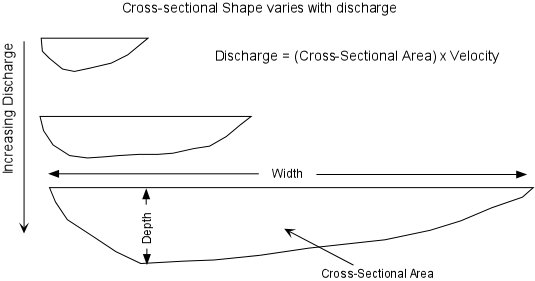
The stream channel is the conduit for water being carried by the stream. The stream can continually adjust its channel shape and path as the amount of water passing through the channel changes The volume of water passing any point on a stream is called the discharge. Discharge is measured in units of volume/time (m3/sec).
Dam & Levee Failures
Stream Systems
Geometry and Dynamics of Stream Channels
|
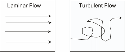 |
The average velocity is the time it takes a given particle of water to traverse a given distance. Stream flow can be either laminar, in which all water molecules travel along similar parallel paths, or turbulent, in which individual particles take irregular paths. Turbulent flow can keep sediment in suspension longer than laminar flow and aids in erosion of the stream bottom. Average linear velocity is generally greater in laminar flow than in turbulent flow. | |
|
As the amount of water in a stream increases, the stream must adjust its velocity and cross sectional area in order to form a balance. Discharge increases as more water is added through rainfall, tributary streams, or from groundwater seeping into the stream. As discharge increases, generally width, depth, and velocity of the stream also increase. Increasing the depth and width of the stream may cause the stream to overflow is channel resulting in a flood. |
|
|
|
|
|
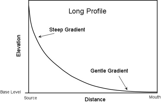
It may seem to be counter to your observations that velocity increases in the downstream direction, since when one observes a mountain stream near the headwaters where the gradient is high, it appears to have a higher velocity than a stream flowing along a gentle gradient. But, the water in the mountain stream is likely flowing in a turbulent manner, due to the large boulders and cobbles which make up the streambed. If the flow is turbulent, then it takes longer for the water to travel the same linear distance, and thus the average velocity is lower. |
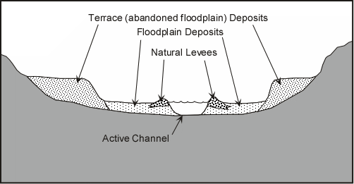
| Floods occur when the discharge of the stream becomes too high to be accommodated in the normal stream channel. When the discharge becomes too high, the stream widens its channel by overtopping its banks and flooding the low-lying areas surrounding the stream. The areas that become flooded are called floodplains. |
|
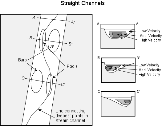
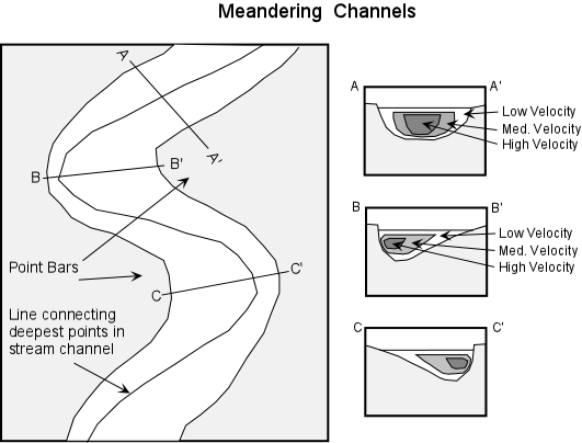
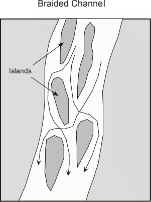
Channel Patterns
|
|
|
|
|
|
|
 |
| Erosion by Streams
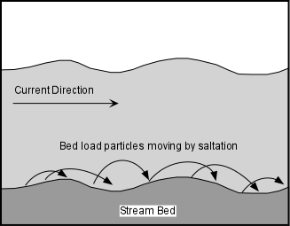
Streams erode because they have the ability to pick up rock fragments and transport them to a new location. The size of the fragments that can be transported depends on the velocity of the stream and whether the flow is laminar or turbulent. Turbulent flow can keep fragments in suspension longer than laminar flow. Streams can also erode by undercutting their banks resulting in mass-wasting processes like slumps or slides. When the undercut material falls into the stream, the fragments can be transported away by the stream. Streams can cut deeper into their channels if the region is uplifted. As they cut deeper into their channels the stream removes the material that once made up the channel bottom and sides. Stream Deposits Sudden decreases in velocity can result in deposition by streams. Within a stream we have seen that the velocity varies with position, and, if sediment gets moved to the lower velocity part of the stream the sediment will come out of suspension and be deposited. Other sudden changes in velocity that affect the whole stream can also occur. For example if the discharge is suddenly increased, as it might be during a flood, the stream will overtop its banks and flow onto the floodplain where the velocity will then suddenly decrease. This results in deposition of such features as levees and floodplains. If the gradient of the stream suddenly changes by emptying into a flat-floored basin, an ocean basin, or a lake, the velocity of the stream will suddenly decrease resulting in deposition of sediment that can no longer be transported. This can result in deposition of such features as alluvial fans and deltas. |
|
|
|
|
|
 |
|
 |
Drainage Systems
|
|
|
|
 |
| |
منابع و ماخذ:
1- فيض نيا ،سادات،1378،بررسی رسوبات ومنشا يابی مخروط افکنه گرمابدشت(استان گلستان)،پايان نامه(کارشناسي ارشد)،دانشگاه شهيد بهشتي،دانشکده علوم زمين.
2-معتمد,احمد,1358,رسوب شناسی2,انتشارات دانشگاه تهران.
3-معتمد,احمد,1372,رسوب شناسی,انتشارات دانشگاه تهران.
4- موسی حرمی,رضا,1379,رسوب شناسی,انتشارات استان قدس رضوی.
 با سلام. از اینکه از این وبلاگ بازدید میفرمایید بسیار خوشحالیم. در این وبلاگ مطالبی درباره علم زمین شناسی به خصوص سنگ شناسی رسوبی و زمین شناسی نفت به حضور شما تقدیم خواهد شد. در این راستا نیازمند همکاری تمامی شما دوستداران علم زمین شناسی هستیم. باعث افتخار ماست که پذیرای نظرات ارزشمند شما باشیم تا با عمل به آنها بتوانیم بر غنای مطالب وبلاگ بیفزاییم.